The History of Belfast
 The site of glorious Belfast, or in Irish Béal Feirsde - meaning Mouth of the Fords or Mouth of the Sandbars, has been occupied since the Bronze Age. However, it wasn't till the 17th century it became a substantial settlement and part of Ireland, when Sir Arthur Chichester established it as a town. The settlers were mainly Protestant English and Scottish migrants and as the years went by Belfast grew to become a a commercial and industrial centre of the 18th and 19th centuries. Especially the linen, ropemaking, tobacco, heavy engineering and shipbuilding businesses were thriving and by the end of the 19th century Belfast had grown larger than Dublin. The Harland and Wolff shipyards, of Titanic fame, became one of the largest shipbuilders in the world. Belfast was however, heavily bombed during WWII and large parts of the city were destroyed.
Since the Government of Ireland Act from 1921 Belfast has been the capital of Northern Ireland and has as a result been the scene of many violent episodes of the sectarian conflict between Roman Catholics and Protestants. The violence peaked between 1969 and 1990 in what became known as The Troubles. Rival paramilitary groups formed on both sides and bombs, shootings and violence became everyday life. In total over 1500 people were killed in political violence in Belfast from 1969 to 2001.
As some of you know, I did my Bachelors thesis on this subject and how the conflict has affected the Northern Irish Identity, so I will probably comment more on this subject in other blogs.
Anyway, that's sort of the basic history of Belfast, lots and lots is missing, but if you wish to dig further into the subject I recommend the dvd Belfast The Birth of a City
featuring the awesome Joe Curran. James, one of my roomies, and I had a great laugh over the dvd and mr Curran yesterday. Nevertheless, the dvd was very informative and enjoyable.
Now, to my personal experiences so far in the glorious city of Belfast...
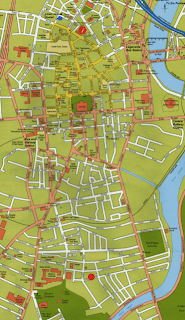
 This is a map of the centre of the city. The red dot near the bottom of the map is where we live.
It's right behind the beautiful Queens University and the botanical gardens creating quite a wonderful scenery for my morning walks. It take about 20mins to get to City Hall, shown on the picture above, which is where you'll find the High Street with fancy shops and great cafés. Our house is right in the student area of town and therefore there are a lot of bars and restaurants. Queens Radio is also situated here.
The city is full of beautiful old houses, many built in the Victorian area, just like our house. And especially the docklands with the old wharfs are cool.

Ingen kommentarer:
Send en kommentar